Can we stay up for a little Santana like sound live in the keys?

Below the pictures from 2017 are some links to Keys stuff that might come in handy to future travelers.
Tuesday, December 27, 2011
Tripadvisor offers some good info if you're driving the keys
The drive from MIA to Key West in a nut shell:
Once you get your car, look for 836 WEST. Smoothly merge and manage your way over the the Left lane and look for 826. The exit is on the left about two miles from the airport. Once you're on it, everything will make sense. 836 turns into 874 and then merges with the turnpike... stay on the turnpike... It'll peter out to US-1 in Florida City. Follow the traffic... It'll lead you right to Key West! Total Turnpike cost: $3.00.
As for the experience. The first half hour of your trip will be a typical US highway experience. Once in Florida City, you have a choice to make. Take Card Sound Road which will come up on your left. (The much hyped Alabama Jacks is located just past the $1.00 toll booth on your right) or stay on US-1 for the 18 mile stretch. It's kinda neat. You'll pass the southern tip of the Everglades although there is a lot of construction for the next 1.5 years with trucks entering and leaving the highway. Expect the stretch to take you about 1/2 hour for the 18 miles. Once off the stretch, welcome to the Florida Keys. You're on Key Largo! (Don't bother looking for Boggy and Bacall... It's not half as romantic as it sounds) If you've taken Card Sound Road, you'll also be joining US-1 on Key Largo. Make up your own mind but you might find the next few miles to be a boring collection of strip plazas, gas stations and souvenir shops. It's time to take notice of the mile marker signs. Key West is basically at Mile Marker 0 so you know how much more you have to drive. At Mile Marker 85, you will be crossing the Snake Creek. This is where it starts to get fun. From the top of the draw-bridge, you can see both the Gulf of Mexico and the Atlantic for the very first time. From there on (until Marathon) it gets quite a bit 'Keysey'. Feel free to stop at any place along the way for refreshments etc. Keep on until you run out of road... Welcome to Key West! The trip will take between 3.5 and 4 hours without stops. Be prepared for an occasional blockage on US-1 for an accident. It happens but not as often as you may fear. Stay strictly to the posted speed limit (or within 5 miles over if you're feeling frisky). US-1 is patrolled by both the Monroe County Sherrif's and the Florida Highway Partol. (Sheriffs: White cars with green strips, FHP: Black cars with tan roofs.) Both love to get ya!
Below a mile marker by mile marker trip guide to make it more pleasurable. Just as an aside... The Florida Keys are made up of over 1700 islands, 32 are inhabitated and by the time you get to Key West, you'll have crossed 42 bridges.
Big traffic tip while driving on US-1: Tune your radio to FM 104.1 - US-1 Radio. Classic rock and current road conditions all along the highway will keep you updated on what's happening down the road. (US-1 can start to be received around Islamorada)
Other radio stations: Talk radio out of Miami is 610 AM and out of Marathon, AM 1300
A great description of the Florida Keys is like this: Think of them as a single, unique city with a population of about 85,000 that's 110 miles long by 1/2 mile wide. That would make US-1 'Main Street'. Expect cars to get on, go a few blocks and get off at the grocery store or gas station. Drive sanely, drive safe.
Here's a run-down on some of the points along the way by mile markers: (Full version can be found at http://www.keyshistory.org/MileMarker... By Jerry Wilkenson)
126.0 = End/Begin two-lane "18 Mile Stretch."
118.0 to 121.0 = Four-lane passing zone
112.5 = MONROE COUNTY LINE - Leave Dade County if southbound.
107.2 = Jewfish Creek drawbridge. Exit/enter Key Largo. Begin "18-Mile Stretch."
106.5 = Card Sound Bridge turnoff to/from Ocean Reef via CR 905 Oceanside. Also an alternate route, $1.00 bridge toll, northbound to Homestead.
104.1 = Caribbean Club, gulfside. The set for the 1948 movie Key Largo was modeled for this location.
103.4 = Marvin Adams Waterway Bridge (The Cut), a canal that connects Atlantic to Florida Bay
102.0 = Telephone microwave towers, gulfside
95 to 100 = This was the early community of Rock Harbor. A small railroad depot was also here.
91.0 = Tavernier Creek Bridge; enter Islamorada; Tavernier Creek Marina, Plantation Marina, gulfside
90.05 = End 4-lane highway if going south.
85.5 = Snake Creek Draw Bridge; Coast Guard Station, gulfside Enter Windley Key
84.2 = Theater of the Sea; Holiday Isle Resort oceanside.
84.0 = Whale Harbor Bridge.
79.8 = Tea Table Relief Bridge.
79.1 = Tea Table Channel Bridge
78.0 = Indian Key Bridge.
77.1 = Lignumvitae Bridge
72.8 = Apogee of Channel #2 bridge
71.4 = Apogee of Channel #5 bridge
70.0 = Fiesta Key KOA and FKAA pumping station
67.5 = Long Key State Park, Oceanside
64.0 = Middle of Long Key Bridge, If southbound, entering the Middle Keys.
61.2 = Tom's Harbor Cut Bridge
60.6 = Tom's Harbor Channel Bridge
59.9 = Enter/leave City of Marathon
58.9 = Grassy Key, Dolphin Research Center
56.2 = Curry Hammock State Park
54.5 = Begin/end 4-lane
53.1 = Vaca Cut Bridge, entering the business district of Marathon next 8 miles.
52.0 = Marathon County Airport, bayside
47.0 = Begin/end of Seven Mile Bridge, Marathon City limits. To Pigeon Key ( old 7-Mile Bridge), gulfside. Pigeon Key visitor's center
44.8 = Pigeon Key, gulf side
40.0 = End/begin Seven Mile Bridge
39.5 = Missouri-Little Duck Channel Bridge
39.0 = Ohio-Missouri Channel Bridge
38.7 = Ohio- Bahia Honda Channel Bridge
37.0 = Begin/end a short section of 4-lane highway.
36.8 = Bahia Honda State Park entrance, oceanside.
36.0 = Bahia Honda Bridge (4-lanes) old railroad camelback bridge, oceanside
35.0 = End/begin 4-lane
33.0 = Spanish Harbor Bridge west end. This potion cut away for good cross-section view.
30.2 = Big Pine Key traffic stop light; gulf to Key Deer Rd. and
29.3 = North Pine Channel Bridge
28.1 = Little Torch Key.
28.0 = Torch Channel Bridge
27.7 = Torch-Ramrod Channel Bridge
26.6 = South Pine Channel Bridge, east end of bridge, oceanside
27.0 = Ramrod Key.
26.0 = Niles Channel Bridge, middle.
25.0 - 24.0 = Summerland Key community
23.5 = Kemp Channel Bridge, east end of bridge, oceanside.
20.2 = Bow Channel Bridge to Sugarloaf Key.
18.6 = Upper Sugarloaf Key
18.8 = Park Channel Bridge
17.8 = North Harris Channel Bridge
17.6 = Harris Gap Channel Bridge
17.5 = Lower Sugarloaf Key
16.3 = Harris Channel Bridge
15.8 = Lower Sugarloaf Channel Bridge
14.6 = Saddlebunch #2 Bridge, Bay Point Subdivision entrance, Oceanside
14.3 = Saddlebunch #3 Bridge, Saddlebunch Shrs./Bluewater Dr., ocean.
13.1 = Saddlebunch #4 Bridge
12.8 = Saddlebunch #5 Bridge
11.4 = Shark Channel Bridge
11.2 = Shark Key
11.0 = Big Coppitt Boat Ramp, oceanside.
10.0 = Big Coppitt Key
9.7 = Rockland Channel Bridge
9.2 = East Rockland Key
8.4 = Begin/end 4-lanes
7.0 = Back gate to NAS, closed, oceanside
6.1 = Boca Chica bridge, middle
5.0 = Stock Island
4.1 = Cow Key Channel Bridge and bear right for
3.9 = Traffic light. End/begin 4-lane. Bear left for Flagler Street; Airport; Martello Towers, Higgs Beach and Casa Marina. Bear right for N. Roosevelt; Truman Avenue, Old Town, Fort Taylor
3.0 = Sears Town shopping plaza
2.3 = Salt Run Bridge, N. Roosevelt, Key West
1.7 = Palm Ave; U.S.C.G. Group; NAS Trumbo
1.0 = About South Street
0.0 = Court House; Key West - This proves that for every ending, there is also a beginning.
You can also find a variety of audio tours to play on your car stereo as you drive through the Keys, which point out attractions and historical sites by mile marker. These can be a great way to pass the time, and make sure you don't miss anything along your way!
Wednesday, November 9, 2011
This is a map of near where most are staying
Since the main office of The Truman Annex has a different location than our actual condo, it makes it hard to pinpoint by address. This zoomable map will give you the general location. We are off of Angela St. near Emma St.
View Larger Map
Old Town Key West is pretty small. If you stay within the area in RED, you'll be close enough to our condo location. Our condo group is approximatly where the "A" is on the map.

Further down the blog is a map showing where each condo is within the complex.
View Larger Map
Old Town Key West is pretty small. If you stay within the area in RED, you'll be close enough to our condo location. Our condo group is approximatly where the "A" is on the map.

Further down the blog is a map showing where each condo is within the complex.
Sunday, October 23, 2011
Up date for anyone new considering a visit to Key West
The dates for the majority of those who have committed (or should be committed) are arriving Saturday February 18 and departing the 25th.
Please feel free to arrive any time you like and leave or not. I will continue to purchase lottery tickets to help facilitate my wishes along those lines.
IF YOU CLICK ANY OF THE LINKS, YOU MAY HAVE TO USE YOUR BROWSER BACK BUTTON TO RETURN TO THIS PAGE.
This link http://www.keystravel.com/Margaritavillas.html should get you to the site many of us booked through. The guy who will answer your phone call is Rand. He lived in Key West many years. His dad it the well known KW personality "Love 22". At least that's what Rand told me. It's best to phone him vs e-mail. Be prepared to have your leg talked off.
He may have some accommodations available at The Truman Annex which is where many of us are staying. The Annex had the best rates I could find for Old Town. The one bedroom condos are not nearly as easy on the budget as splitting a two bed with friends. I'm guessing $160 a night splitting the two bedroom vs $289 in the one bedroom. I think Rand works through this main Truman annex site http://www.compass-realty.com/
If you going the one bedroom route I'd suggest looking at http://www.edenhouse.com/ . It's a pretty cool throwback hotel. You'd like it if you are a Hippy. Nice free happy hour poolside every day. It's a bit far from the Truman Annex but nothing in Old Town is too far from anything else in my opinion. I think I would want to stay at The Eden House if cost were not a consideration.
Also consider http://www.roselanevillas.com/. Much closer to the action by about 6 blocks. One block off Duval. 1, 2 and 3 bedroom condo style.
You can stay in New Town a bit more cost effective but then you have travel to Old Town issues. Most larger New Town hotels have shuttle service.
Here's a link to many many places to stay. http://www.keywest.com/accommod.html It also has all sorts on link and info about KW.
Thursday, September 29, 2011
Showing the week of 2/18/12 - 2/28/12 at The Red Barn Theater
Forbidden Broadway, written and conceived by Gerard Alessandrini. This Off-Broadway satirical musical revue has been running in various versions in New York for 25 years. It sharply spoofs show tunes, characters and plots of popular Broadway musicals with snappy lyrics and fabulous costumes. In 2006, the show was awarded Tony honors for Excellence in Theatre. Forbidden Broadway has been seen in more than 200 US cities as well as London, Tokyo, Singapore and Sydney and now comes to Key West! Red Barn Theatre’s production is the first one to be licensed to use a local cast. Audience favorites Eric Cole, J.B. McLendon, Gayla Morgan and Marjorie Paul-Shook make up the cast of this hilarious evening. Becky Barta, veteran of many Forbidden Broadway shows, will direct.

http://redbarntheatre.com/

http://redbarntheatre.com/
Friday, July 1, 2011
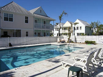
Tuesday, June 7, 2011
Some pics of our shared pool
I've looked at some aerial views of this location recently. It look like there may be increased shade due to palm tree growth.


Subscribe to:
Posts (Atom)